A map can speak many languages, reach many audiences — and significantly support the stewardship of natural resources. Where geospatial data is needed, geographic information systems (GIS) are an important tool for building maps that locate information related to flora and fauna, cultural preservation, and recreation, among other applications.
Since 2013, the Ancestral Lands Gallup, N.M., office of the nonprofit Southwest Conservation Corps has been recruiting and training Native young adults in and around the Navajo Nation to participate in numerous conservation projects, such as removing invasive species, restoration, erosion control, and sustainable farming. In 2014, collecting geospatial data for various government agencies via GIS was added to the scope of the project.
Most Ancestral Lands participants enter the program with no prior work experience, and during their season with the project can become effective GIS technicians with a valuable skill set. This opportunity is especially important on the Navajo Nation, where the unemployment rate is 40 percent. For many young adults, programs like Ancestral Lands are essential in providing technical skills, leadership training, knowledge of cultural and conservation practices, and mentorship while engaging them in positive work for their communities.
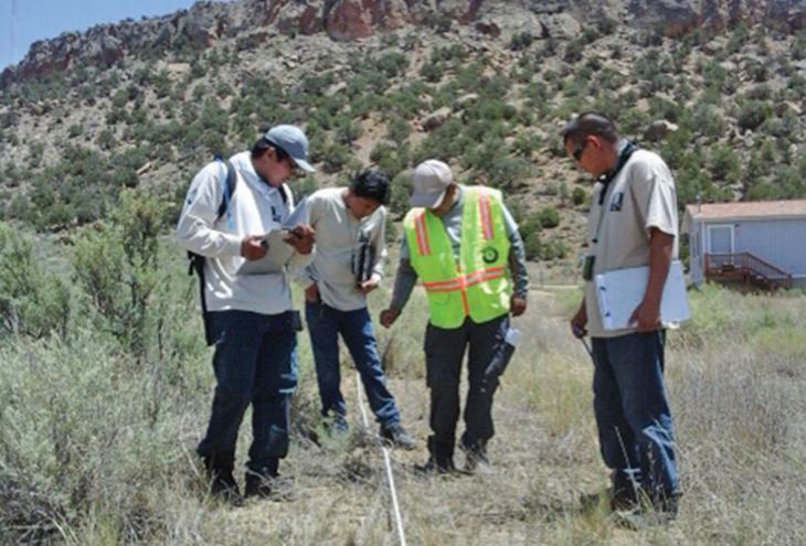
Ancestral Lands participants get hands-on training in field data collecting, editing, and management using Esri ArcGIS software
Specifically, Ancestral Lands participants get hands-on training in field data collecting, editing, and management using Esri ArcGIS software. They also undergo training in botany and plant identification by Northern Arizona University professors who offer a workshop in the field. All participants receive various other trainings and certifications, such as Leave No Trace, Wilderness First Responder, first aid, and CPR. Crews also learn methods of vegetation monitoring, line-point intercept, and plot monitoring in conjunction with using mobile GIS for data collecting and reference. Depending on the length of service, corps members receive an AmeriCorps education award.
transect surveys, and line-point intercept
predisturbance vegetation training
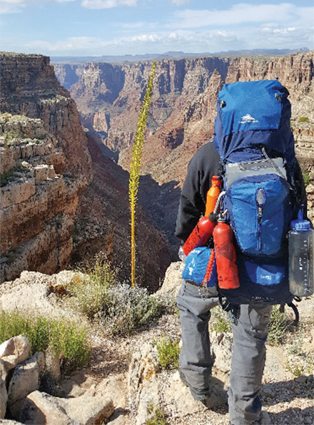
in Tse Bonito, N.M.; above: a GIS
crew leader at the start of the trail
before descending into the
Little Colorado River Gorge
A major aspect of the program is invasive weed inventory because if these invaders are left unchecked, areas that were once home to native grasslands could become overgrown. The inventory of noxious species involves collecting spatial data — like the exact coordinates, acreage, pictures, and phenology — for agencies such as the Bureau of Land Management and the Bureau of Indian Affairs.
One area that had never been inventoried was the Little Colorado River Gorge. Crews had to hike in and spend up to seven nights inside the canyon. Another was Cataract Canyon in Utah. Here, crews spent two weeks rafting 80-plus miles on the Colorado River, stopping at key areas to map and remove invasive species. GIS data from the Cataract Canyon project is collected and analyzed annually to determine the success of mitigation efforts. During one season the crew was able to report geospatial data on a large infestation of Tribulus terrestris (bullheads/goatheads), an invasive European species, prompting local natural resource managers to begin immediate mitigation control efforts.
Ancestral Lands crews also collected both quantitative and qualitative data for the Navajo-Gallup Water Supply Project and predisturbance vegetation spatial data for the Bureau of Reclamation (BOR). Plot vegetation photos were taken and attached to vector features along 47 miles of the proposed waterline route. The vegetation data would be used to reclaim and reseed native plants after construction of pipelines to provide fresh water to the Navajo Nation and surrounding tribal nations.
This year’s GIS projects will include invasive inventory of the Chuska, Carrizo, and Navajo Mountains. Also in the mix are another Cataract Canyon raft trip and BOR vegetation monitoring. Learn more about the program and see a map journal of all the GIS projects at ancestrallands.org.